


Reading the River
(written by Carla Swerman, Archives staff)
“Few things in life stay the same.” How true! Yet, something that has defied change for 145 years is the river gauge at the south end of Riverside Park. While the technology for reading the Mississippi River’s water levels has advanced over time, the equipment itself has stood at almost the very same spot for 145 years and boasts reasonably consistent readings throughout the decades. Even so, the last 45 years are shrouded in some mystery.
(Photo by Carla Swerman)
The river gauge was initially attached to a pile driven into the Mississippi River near a flour mill at the foot of Mount Vernon St. Its first reading was taken on June 17, 1873, by the US Army Signal Corps, the same organization that took the first official La Crosse weather observation in October of 1872 (see my 2017 blog post about the La Crosse National Weather Service office). For the next 70 years, personnel from the US Weather Bureau in La Crosse were responsible for visually reading the staff gauge, a “vertical ruler,” each day.
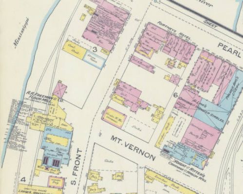
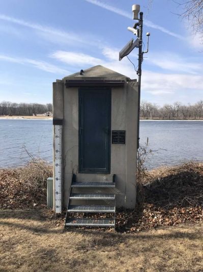
Mount Vernon St. was a short street that connected Second Street to the Mississippi River, but met its demise around 1980 with the building of the La Crosse Center. Yet, the river gauge remained at the same spot, near today’s Waterfront Restaurant and Tavern. The gauge shelter is visible when traveling on the south end of the Riverside Park walkway. [1887 Sanborn fire insurance map]
The “zero” reading was established at 627.3 feet MSL (mean sea level). What is considered “stage zero,” the bottom of the river bed or the lowest point at which water will get into a river, varies from community to community because it is arbitrarily set by local experts. Typically, in La Crosse, a 12-foot water stage is considered flooding, but it is 13 feet at Winona, MN, 15 feet at Prairie du Chien, and 47 feet at Hokah, MN.
Differences aside, on Feb. 2, 1885, La Crosse leaders either lowered the zero reading to 625.1 MSL or moved the gauge. Regardless of what happened, all previous records were then adjusted to compensate for the 2.2 foot difference. With that, a flood of 17.4 feet on June 19, 1880, still ranks as one of the top crests in La Crosse. Of course, there was no lock and dam system at that time; if there had been, the crest would not have been as momentous.
Records indicate that the gauge survived that 1880 flood. So, when construction began in 1889 on a wagon bridge between Mt. Vernon St. and Barron’s Island (now Pettibone Park), all of it was to be at least 10 feet higher than the 1880 crest. By the fall of 1891, the U.S. Army Corps of Engineers (COE) cut a new gauge into the stone of the wagon bridge’s pier. Only 300 feet away from the original river gauge, this gauge’s “stage zero” was set 1.2 feet higher to correspond with the lowest water measurement of 1.2 on Aug. 26, 1877. With that adjustment, the 1880 crest now measured 16.2 rather than 17.4 feet.
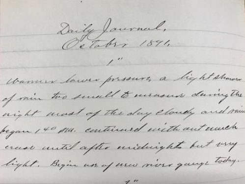
The last sentence of this October 1, 1891, U.S. Weather Bureau record indicates the first use of the U.S. Army Corps of Engineers’ Mt. Vernon Gauge Station.
Between then and the early 1930’s, several more minor adjustments were made to “stage zero” and several different kinds of gauges were used, but the locale for “reading the river” remained constant. It made sense then to build a permanent shelter for the gauging equipment. The COE did so in 1934. At the same time, a concrete stilling well with two intake pipes was installed. A Styrofoam disc that floated on top of the water was connected by a chain to the equipment inside the shelter so that fluctuations could be recorded.
In 1939, when the wagon bridge was destroyed and a new bridge was built across the Mississippi, the gauge and shelter were not affected. But, a technological change came about in 1942 when a data logger and transmitter were installed inside the shelter. The fluctuations in the floating disc resulted in buzzes that could be heard via a telephone line. Personnel no longer had to go to the shelter to obtain readings.
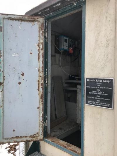
With the door of the shelter ajar, the data logger and transmitter that provide automated readings are visible in the upper left. When water levels fall below flood stage and a non-automated reading is desired, personnel can climb down a ladder that is housed in the floor opening. (Photo by Carla Swerman)
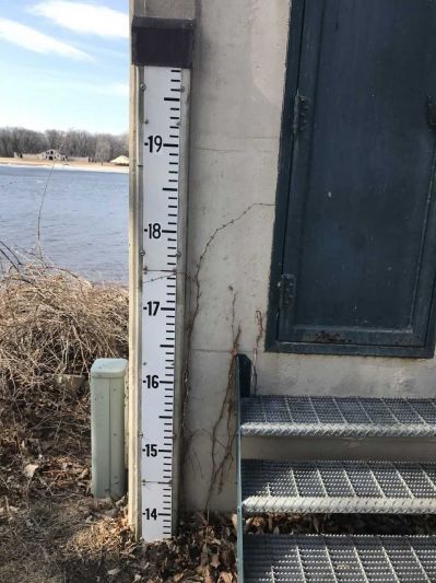
The staff gauge outside the shelter is used when reading river stages that are above flood level. (Photo by Carla Swerman)
No matter the slight fluctuations in “stage zero” over the decades, the highest reading ever recorded was in April of 1965 when the Mississippi crested at an official 17.9 feet. Because of that flooding, in December 1966, plans were unveiled for clean-up and renovation of the entire “harborview” of downtown La Crosse in the hopes that any future floods would not be as damaging.
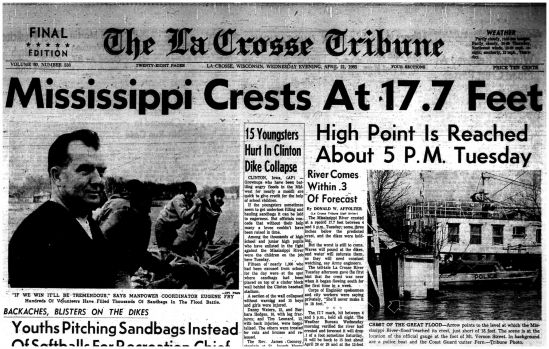
The river gauge shelter is depicted in the lower right of this early account of the 17.9-foot flood. The 17.7 feet in the headline was an early account.
In 1973, believing that the shelter would be demolished during the renovation, the COE installed another stilling well with connecting intake pipes at the water treatment facility at Isle La Plume, 0.9 miles south. So, 100 years later, La Crosse now had two river gauges.
But, the history of those two gauges over the next 40 years is filled with mysteries that may never be solved. Both the COE and National Weather Service (NWS) have limited documentation of either river gauge from 1973 through 2015. What information is available indicates that the two agencies were not always aware of which gauge the other was using for official readings. And, due to varying circumstances, both discovered that there were discrepancies between the measurements taken at the two sites.
Eventually, the COE realized that the Riverside shelter had never been torn down. So, on April 16, 2015, the COE moved all the Isle La Plume equipment back to the Riverside Park locale. To this day, both COE and NWS readings come solely from the “birth home” of La Crosse’s site for measuring the Mississippi.