


Find Your Place 100+ Years Ago with Sanborn Maps Online
(written by David Kranz, Archives staff)
Sometimes it can be hard to imagine just what a building, street, or neighborhood looked like a century ago. Historic photos are great, but we don’t have photos of every house and business.
One of the best tools researchers have to help with this are maps made by insurance companies in the late 1800s through the mid-1900s. Fires were an all-too-common danger, sometimes wiping out major portions of a block. Insurance companies went to great lengths to know what they were insuring. They periodically sent out map-making teams to gather information about the buildings in cities they served. La Crosse was one of those cities.
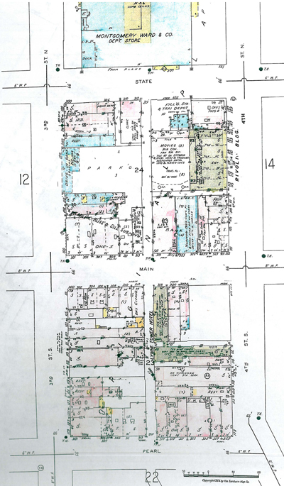
At the La Crosse Public Library Archives, we have a number of these old insurance maps on microfilm. We have Sanborn Map Co. maps from 1884, 1887, 1891, 1906, 1944/1950 on microfilm, as well as physical versions of the 1944 map. We also have a copy of the 1954 map with updates added into the 1960s. These can be a great way to get a visual sense of the development and changes that took place in the city over time.
The maps can be quite specific, too, not only in representing graphically the dimensions of buildings and spaces around them, but also in the details of the construction materials and activities that took place there.
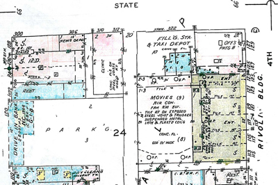
This close-up image of the corner of 4th and State Streets shows the Rivoli Theater and nearby businesses. There used to be a filling station and taxi depot at 322 State St. You can see notes written in regarding building materials such as “Tile,” “Stone,” and “Lathe & Plaster Ceil’g.”
There is a map key that explains all the little marks that indicate numbers of windows, aspects of the firewalls, and what the different color shades meant.
We welcome you to visit the LPL Archives to take a look at places of interest to you on our Sanborn maps. Additionally, some of these Sanborn maps are available online, through the website La Crosse History Unbound. From the Maps page, you can scroll down to the link “Sanborn Maps of La Crosse, Wisconsin, and Other Wisconsin Cities”. Clicking that link takes you to a digital collection that includes Sanborn maps of La Crosse.