


High Waters in '65
(written by Carla Swerman, Archives staff)
The past three summers, water levels have been high on area waterways. With the Mississippi River in La Crosse hovering around 10 feet last month (July 2018), this question often surfaced: How high can the water get before a flood occurs?
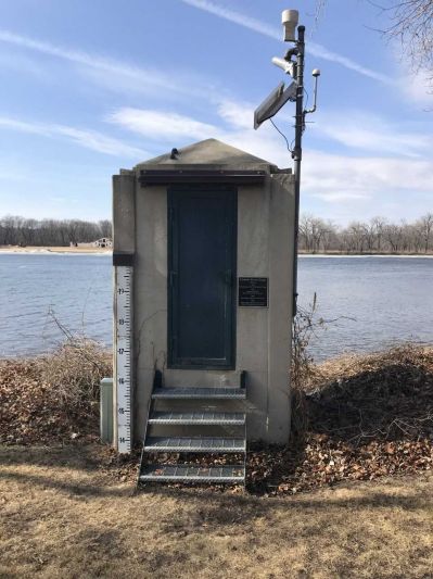
While flood stage varies from community to community, here in La Crosse, flooding of the Mississippi is considered to occur at 12 feet. To learn more about river stages as well as the historic river gauge that “reads the river” on the south end of La Crosse’s Riverside Park, click here: http://archives.lacrosselibrary.org/blog/reading-the-river/
(Photo by Carla Swerman)
The 145-year-old river gauge – with the installation of new and more technologically-advanced equipment over the decades – measured its highest elevation on April 21, 1965: 17.9 feet! That year, record snowmelt and heavy rains affected nearly all the tributaries to the Mississippi. As early as March 9, 1965, flooding was accurately forecast to be at 13.5 feet in early April. Already by April 8th, the predictions grew more alarming with a 17-foot crest expected on April 22. True to that prediction, the Mississippi crested at what was thought to be 17.7 feet on April 20, thirteen years to the day since the 1952 record of 15.3 feet had been set. But, on May 1, 1965, the La Crosse Weather Bureau announced that the crest had actually reached 17.9 feet at noon on April 21.
Thirty-six years later, the La Crosse Parks and Recreation Department director at the time, Eugene Fry, stated that “It looked like an ocean had come to town.”
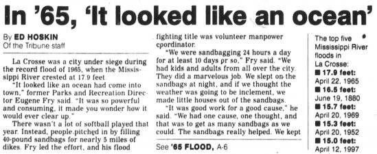
La Crosse Tribune 15 April 2001
Mother Nature’s “ocean” couldn’t be vanquished, even with the 395,000 sandbags and 4.8 miles of dikes that were built by community residents, including women and youth, volunteers from other communities and states, and the National Guard.
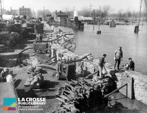
Front Street North in the vicinity of the Oktoberfest grounds - Trust Point building in deep background on left
Despite these efforts, a few days before the crest, businesses along the Causeway were surrounded by water, 25 homes on the south end of La Crosse’s North Side were flooded, two runways at the airport were flooded, the basement of the W.A. Roosevelt Building (Trust Point) at 230 N. Front St. exploded due to water pressure, and many other downtown businesses sustained sizeable damages.
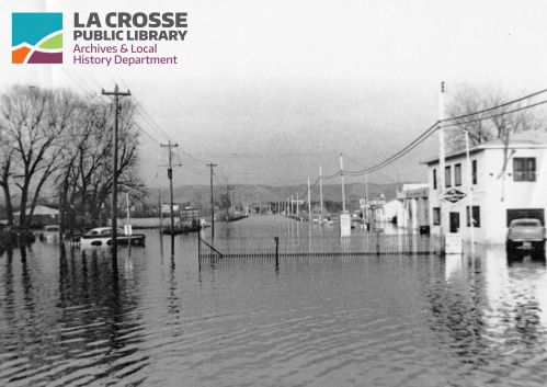
Flooding at the intersections of Bainbridge and Clinton Streets on French Island closed the Clinton Street Bridge on April 17.
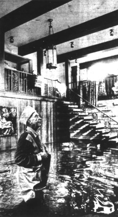
From La Crosse Tribune 22 April 1965: Despite E.H. “Boss” Schultz’s persistent efforts to save his $100,000 home on French Island with wood barricades and beam-reinforced dikes, nearly three feet of water spewed up from the floor of the house. This Associated Press photo of him in his living room garnered international attention.
Obviously, the day-to-day lives of La Crosse residents were markedly altered. Many had to evacuate their homes; all had to endure limited or altered travel by road, train, and/or air as well as a lack of reliable telephone service and concerns over potentially unsafe drinking water. In a sense, the flood of 1965 was the “worst of times,” yet it was also the “best of times” with families, friends, and neighbors united in the cause. Amidst helping one another weather the flood, memories were made.

Two young men maneuvered through water that had seeped from a Highway 53 dike
Another “blessing” of La Crosse’s most devastating flood, which cost $151,448 for flood control and the clean-up of public property (only), is that it led to the revitalization of the downtown area. Many flood-damaged buildings west of Second Street between State and Mount Vernon Streets as well as east of the Mississippi River were removed as part of the Harborview Plaza redevelopment project. With the building of new stores, offices, and apartments, efforts were taken to prevent damages from any future flooding. The resulting beautification and commercial development now make the flood of 1965 “water under the bridge.”
To see a listing of the top 20 Mississippi River crests in La Crosse, click on this link to the National Weather Service of La Crosse: https://water.weather.gov/ahps2/hydrograph.php?wfo=arx&gage=lacw3 If you are interested in learning more about other La Crosse-area floods and/or view photos of flooding, consider visiting the La Crosse Public Library’s Archives Department at 800 Main Street.