

The Heart of Downtown, La Crosse
(written by Jenny DeRocher, Archives Staff)
As our built environment continues to change around us every day, it’s important to check in and think about what spaces around us used to look like and what caused them to change. This connects us to our city’s history and our current community—in other words, our local cultural heritage. Some changes may be on accident, while others are made purposefully. Thanks to historic materials collected at the La Crosse Public Library Archives, we can often times find out what these reasons were.
The Archives holds historic photographs of streets, buildings, houses, people, parks, festivals, parades—the list can go on. No matter the reason these photographs were taken, they track how places in the La Crosse area have changed over time. The streets go from dirt to brick to black top. Sometimes photographs can even show why a space changed—for instance, we have photographs of fires and floods. In some cases we even have photos of the exact moment a demolition vehicle begins its work on a building.
Let’s look at just one intersection in La Crosse’s downtown as an example: Main and 3rd Streets. One local historian, Leslie Crocker, refers to this intersection as the “Heart of Downtown.” Crocker says this because it has historically served as an important focal point in the city’s downtown business and cultural district. However, this intersection has changed so much that it may be hard to picture it this way now. Thankfully, the Archives has photographs to track how this intersection has changed.
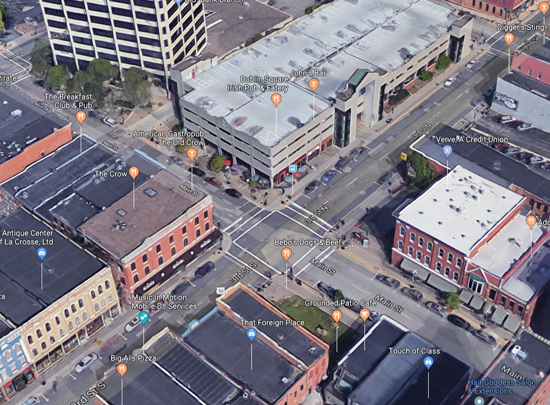
A Google Maps view (facing north) of Main & 3rd Streets, historically the heart of downtown, La Crosse.
Though there are no photographs of what La Crosse looked like before Euro-American colonization in the 1840s, there are many sources that described it as a prairie, hence the original name of the town, Prairie La Crosse. This land—including the intersection of Main & 3rd—was stewarded by the local Ho-Chunk and their ancestors for generations before colonization. As the federal government forcibly removed the Ho-Chunk upriver to Minnesota, Nathan Myrick’s fur trading post brought other businesses and the lumber trade brought travelers on the river. La Crosse was founded on these terms and the landscape changed dramatically.
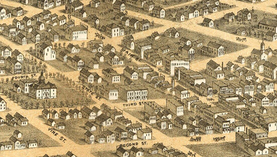
A small snapshot of the larger 1867 bird’s eye view of La Crosse, Wisconsin drawn by A. Ruger and published by Chicago Lithographing Co. This cropped piece shows the intersection of Main & 3rd (facing east). To the left, you can see the original La Crosse County Court House. Though this is an artist’s rendering, it represents the general appearance of the city at the time. See the full image here.
Let’s explore the history of each corner at the intersection of Main & 3rd. First, we’ll look at the current southeast corner: the empty lot next to Grounded Coffee.
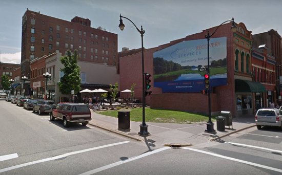
The southeast corner of 3rd and Main Streets, as seen on Google Maps Street View. Why would there be a large empty grass lot in what is called the Heart of Downtown?
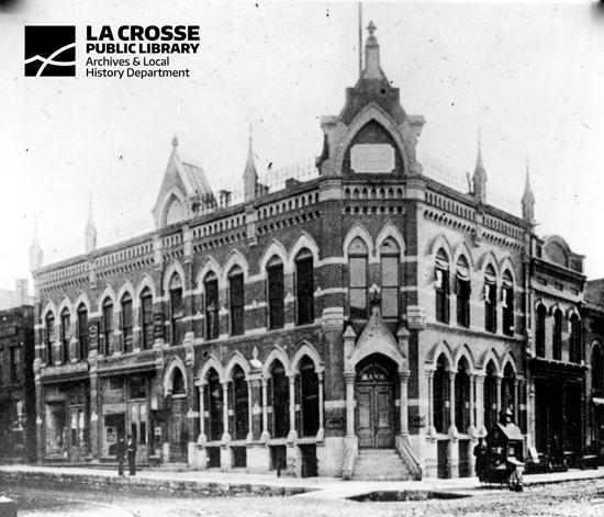
Originally at this corner was the La Crosse National Bank building, which was built in 1881. The bank was co-founded by prominent financiers, men like Samuel Seward Burton and Gideon Hixon. Though this bank eventually moved locations, the building continued to house a variety of businesses well into the mid-1900s, such as barbershops, restaurants, a shoe store, etc. This photograph is undated, but notice the dirt streets and clothes of the few people on the sidewalks. From these details, we can guess that this is the late 1800s.
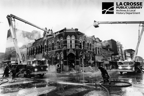
In late December of 1979, a fire destroyed the building. It was later determined that an arsonist started the fire, at direction of one of the business owners in the building who was attempting to commit insurance fraud. This photo shows the morning after the fire. Firefighters fought the blaze for over 7 hours. Luckily, no one was injured in the blaze or fighting it. After the fire, the building was razed. The lot is still empty, now mostly being used by food trucks and stands.
Next, let’s look at another corner of the intersection, one that has faced many changes aesthetically, though not structurally.
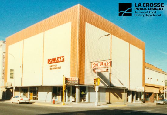
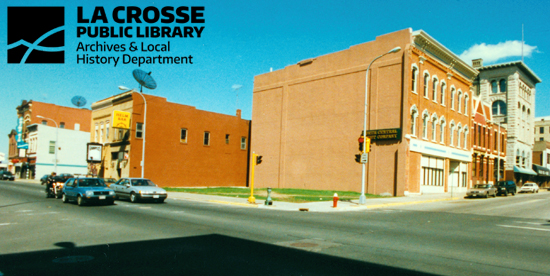
Before scrolling down, can you figure out which corner this is? This photograph is from 1999—not that long ago. Many readers may remember exactly what corner this is and what the building looks like now.
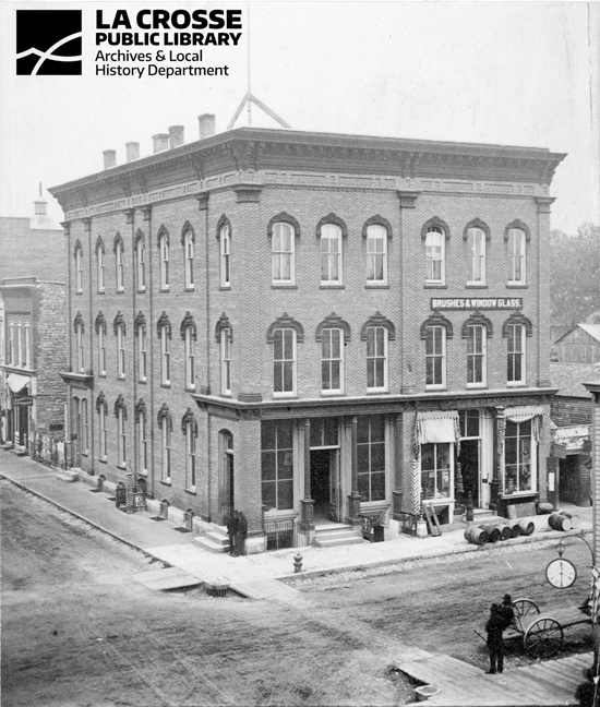
 Originally built in 1868 (just one year after the bird’s eye view from above was drawn), this building—known as the Rodolf Building—was the center of the city’s social life for many years. It was home of several organizations, including the Young Men’s Library Association, who would later become the La Crosse Public Library. In 1872, the La Crosse Business College opened here, where it stayed for many years, acting as one of the longest residing tenants. The Rodolf building is one of the oldest surviving examples of Commercial Italianate architecture in the city. It compliments many other buildings on that stretch of 3rd Street. Photo is courtesy of the UWL Murphy Library Special Collections & Area Research Center.
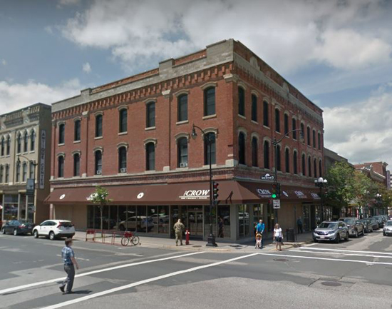
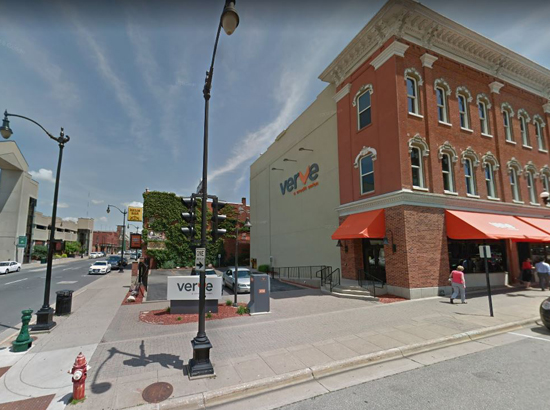
The southwest corner of Main and 3rd Steets, taken from Google Maps Street View. The metal sheeting from the first photograph was added to the building in the 1960s. The vintage metal false-front was applied in an attempt to modernize the building. The 1960s and 1970s were a time of Urban Renewal for La Crosse. During these years, the city said good bye to many historic buildings—whether they were demolished or covered up with sheet metal. In the early 2000s, the metal was removed and today we are able to see the building in its original form. It currently holds The Crow, a gastropub, on the street level portion of the building.
What about this next building? Which corner is this?
This photograph is from circa 1875, when the building had tenants such as the T.H. Spence Drug Company (right, street-level) and the Birney Barbershop (left, in the basement), both of which were significant for their own reasons. Birney’s shop was in this building from the years 1870-1884. Learn more about John Birney here, in a blog post about his historic influence on the community. Spence’s company was founded in 1874 and would later become the Spence-McCord Drug Company. For many years, T.H. Spence was among the only wholesale drug companies in La Crosse. The company later relocated to Front Street.
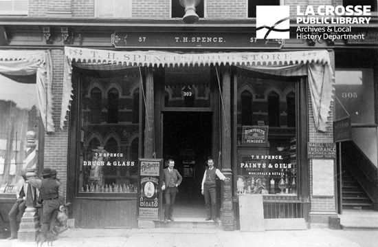
The barber pole to the left has Birney’s name on it, likely with three of his hired barbers hanging around for the photograph. T.H. Spence’s Drug Store is the center piece of the photo, which was likely taken in the late 1870s or early 1880s. You can see on the right side of the photograph that the building was extended to the right (east, further up Main St.) since the photo above was taken.
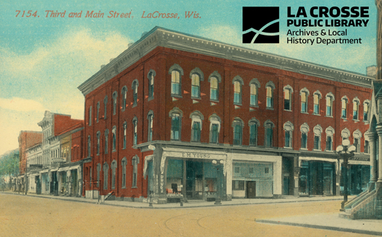
An undated postcard showing the whole length of the updated building. Using the tenant E.M. Young as a guide, this postcard is likely from around 1910.
In 1981, the two left sections (the older, original portion) of the building were razed due to structural problems. Today, this area serves as the Verve Credit Union’s parking lot.
The northeast corner of Main and 3rd Streets, captured from Google Maps Street View.
Before we go into its history, let’s just take a look at the current northwest corner block for a moment.
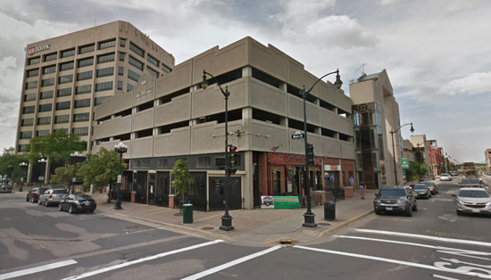
The northwest corner of 3rd and Main Streets, captured from Google Maps Street View. What is different about this block than the other three sides of this intersection? There are no historic buildings on the entire block. With Urban Renewal, La Crosse’s downtown was facing major changes in the 1960s and 1970s. All over the country, towns and cities were razing buildings to replace with new, larger, and often Brutalist buildings that were more practical and less costly (Brutalism architecture is primarily recognized as large, concrete, and imposing). La Crosse was no exception.
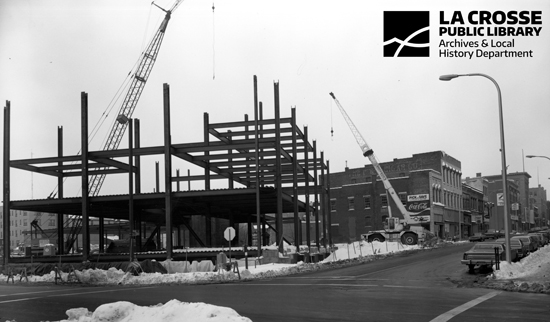
After the damage from the 1965 flood, Brutalism was embraced here in La Crosse. The buildings closest to the river, along Front and 2nd Streets were demolished. This was an era of commercial development. Buildings like the Radisson Hotel and the La Crosse Center were built at this time. Also developed in the 1970s is the block that is now the U.S. Bank Building, a parking ramp, and a few restaurants and bars at the northwest corner of Main & 3rd. This photograph is from the 1970s, taken while the current U.S. Bank building was in construction. In the background, behind the crane to the right, you can see a stretch of historic buildings at the northwest corner of Main & 3rd. These buildings were later demolished to make room for the parking ramp.
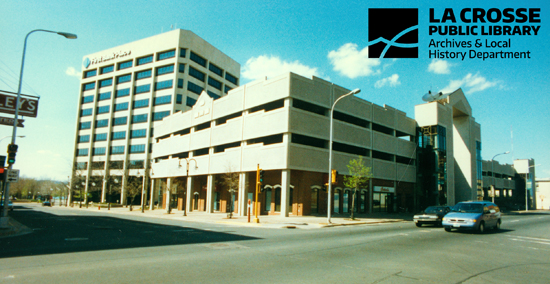
This 1999 photo shows the completed parking ramp. To soften the structure and make use of the street-level space, the first story of the ramp at the northwest corner of Main & 3rd was designed to hold businesses. Today, this is Dublin Square, John’s Bar, and a few other restaurants.
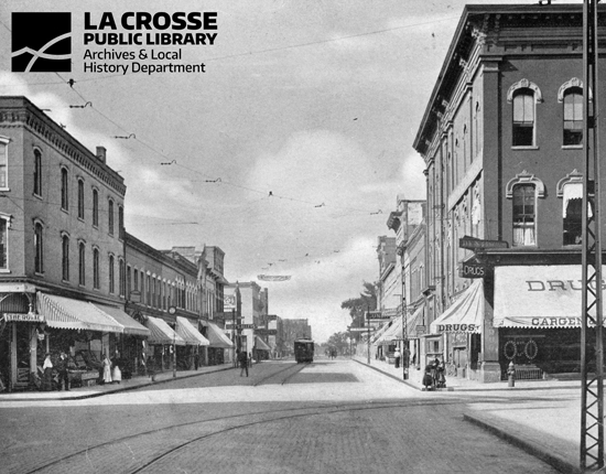
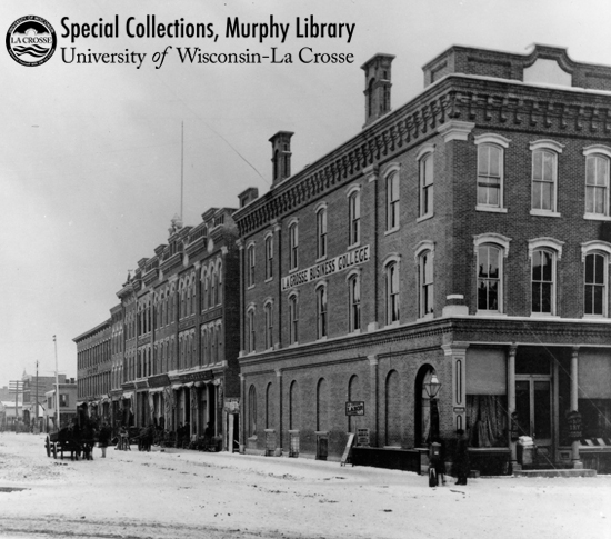
There are not many historic photos of this area before the 1970s, but here is a street view looking north on 3rd Street from the intersection of 3rd & Main. This was likely taken in the late 1800s. Looking at the sidewalk activity and names on the awnings, you can see the variety of businesses on this street around the turn of the century.
As you look at the built environment around you, try thinking about how and why spaces have changed through the years. Every street corner has its own story.
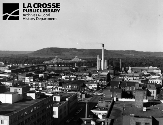
An overview of downtown La Crosse looking west towards the river, probably from St. Joseph’s Cathedral.