


La Crosse River Marsh: History of an Urban Wetland
City's Comprehensive Plan & the Marsh
In reading “Confluence: The La Crosse Comprehensive Plan,” the city’s most current master plan (2001-2002), it is clear that the La Crosse River marsh is highly valued as a natural resource but remains a possible target of conflicting uses. This resource cites the importance of protecting the remaining wetlands and identifying opportunities to restore degraded wetlands (P1-9; P1-11, P2-3), yet noting that major commercial road corridors are becoming congested and that “…Limited north-south road capacity and natural barriers, such as The Marsh, pose treats to maintaining good access between downtown and the I-90 corridor, which is becoming increasingly important to the economic health of the City.” (P2-4).
Current Natural Phenomenon
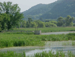 The La Crosse River Marsh is a wonderful example of a natural wetland. This type of wetland has a natural supply of water. In this case the level of the marsh depends on rainfall amounts as well as the level of the La Crosse River. Marshes also usually have a greater variety of animals and plants than do lakes, grasslands or forests. They have characteristic plants that grow in distinct zones or layers. The highest canopy of plants includes cattails. On the water surface are duckweeds, the world’s smallest floating plants, which are a great source of food for waterfowl. There are a lot of algae (much of it microscopic) between the water surface and the soil at the bottom.
According to the state wetland inventory, the La Crosse River Marsh is 1,077 acres and is included in the Mississippi River Floodplain. This kind of a marsh is called a riparian marsh because it occurs along a river. It is extremely important for many reasons including the fact that it absorbs excess water when the river level is high and releases water when the river level is low. This helps to prevent floods and droughts.
From the inventory done by the Department of Natural Resources, the marsh is home to a great amount of biodiversity including:
Non Seed Plants
Algae (green and bluegreen), moss, fungi (puffballs, mushrooms, smuts, ergot, molds, mildew, shelf fungi), lichens, horsetails and ferns.
Seed Plants
At least 100 different kinds including trees (Oak, Cottonwood, Basswood, Silver Maple), vines, water plants (cattails, duckweeds, sedges, arrowhead), grasses, mints (Ground Ivy, Motherwort), asters (Black-eyed Susan, Burdock) and shrubs (Buttonbush, Dogwood)
Invertebrates
Protozoans, sponges, earthworms, leeches, flatworms, roundworms, clams, snails, crustaceans (shrimp, crayfish, water fleas), spiders, mites, ticks, harvestmen, millipedes, centipedes and insects (Mayflies, Dragonflies, Crickets, Grasshoppers, Termites, Leaf Hoppers, Cicadas, True Bugs, Flies, Mosquitoes, Wasps, Bees, Ants)
Vertebrates
24 different species of mammals including beaver, muskrat, red fox and river otter
139 different species of breeding and migratory birds have been identified including such birds as the Blue-winged Teal, the Yellow-headed Blackbird, the Red-tailed Hawk, the Brown Thrasher and the Great Blue Heron
9 species of reptiles including Snapping Turtles, Painted Turtles and Garter Snakes
At least 6 species of amphibians including Chorus Frogs, American Toads, Spring Peepers, Leopard Frogs and Green Frogs.
53 species of fish including Bowfin, Northern Pike, Perch and Sunfish
There is current community interest in preservation and restoration of the La Crosse River wetlands. The Mississippi Valley Conservancy, City of Onalaska, Gundersen Lutheran and the City of La Crosse have been involved in a habitat conservation and restoration project upriver from Valley View Mall.
La Crosse River Marsh continues to be a subject of study for students. You can listen to a discussion of the ecological history of the marsh with UW-L faculty, students and others.
Background on Marsh Issues
The La Crosse River physically divides La Crosse into a north and south side. Because of the geographical features surrounding La Crosse, community leaders feel pressured to continue to have La Crosse grow and to bring in a wider tax base. As a result, land use of natural areas such as the marsh have been repeatedly questioned over time.
Archaeological studies state that human occupancy of the margins of the Lower La Crosse River Valley for the past 9,000 years is well documented.1 A single artifact has also been recovered from the floodplain of the La Crosse River that suggests use prior to this time. These sites are located on the high glacial outwash terraces at the margins of the marsh area. “The Lower La Crosse River Valley is and has been a dynamic geomorphological environment as well as, potentially, a dynamic archaeological environment.”2
Filling in the wetland area in and around the city has been a serious topic among governmental and business leaders in the community since the end of World War I. At this time, John Nolen, nationally noted landscape architect and city planner, devised a new city plan for La Crosse as part of the War Memorial efforts.3
The city council didn’t make any real attempt at using the wetland for industrial space until a second causeway called Lang Drive was completed through the marsh in 1932. This additional north-south corridor gave renewed hope to building an industrial park in the marsh area. In the 1940s, the La Crosse City Planning Commission, under the direction of the Common Council, served as the liaison with the Chicago engineering firm of Alvord, Burdick & Howson to develop a plan for filling in the La Crosse River marsh in the city. The 1946 proposal called for filling in 468 acres of wetlands for industrial and commercial use, redirecting and straightening the La Crosse River, and routing flood waters to the Black River.
In the summer of 1948, Max Bemel broke ground in his industrial addition on the west side of Causeway Blvd. It marked the beginning of building development in this area which was “reclaimed” by filling with sand from the Black River.4; The first structure to go up was a Piggly-Wiggly grocery store on the southwest corner of Copeland Ave. and Causeway Blvd. Clearly, this was what governmental and business leaders in the community wanted to see.
The issues below are the larger topics most widely discussed in reference to the marsh: transportation and recreation. Please visit the bibliography of digitized resources to see a more comprehensive list of written literature pertaining to specific topics. The digitized resources are full text and speak more specifically than we do here.
La Crosse River Channel
According to Anthony Godfrey in A Historical Analysis of the Lower La Crosse River 1841-Present the La Crosse River originally had two channels. The northern channel left the main channel in the SW ¼ of Section 29 and meandered westward until it reached the Black River, near the present day junction of Milwaukee and Car streets. The northern channel flowed until approximately 1885 when it was obstructed and eventually eliminated by railroad business. The southern channel largely followed its current course to the Mississippi River except that the mouth emptied in farther south and inland. The southernmost channel dipped to a point approximately just north of where Front and Pine streets would intersect today. The southern portion of this river stayed in this channel until around 1885.5
Silver Creek, an outlet of the La Crosse River, and the agricultural drainage ditch system were blocked by the construction of Lang Drive in 1932. As a result, Godfrey argues, “water began to slowly back up and the landscape went from a productive well-drained tillable area to marshland in the span of a decade or more”.6 Read Godfrey’s analysis for more specific information about the drainage patterns of the lower La Crosse River over time.
Transportation Issues - Railroads
While the first railroad to reach La Crosse arrived in 1858, it wasn’t until 1876 when Congress approved the first railroad bridge to cross the Mississippi River at La Crosse for the Milwaukee & St. Paul Railroad (later called the Milwaukee Road).
Ten years after the railroad bridge was constructed across the Mississippi River, a railroad boom literally hit La Crosse. Each line built their own track, embankments, trestles and blocked parts of the La Crosse River. By the end of the nineteenth century, La Crosse was serviced by four major transcontinental railroad lines handling both freight and passengers. All of these lines crossed the La Crosse River and some traversed through the marsh to get to downtown La Crosse.
In 1873 the Green Bay and North Western formed a contract to use each other’s tracks so the Green Bay could get into Winona and the North Western could get into La Crosse, using a place called Winona Junction where the town of Medary is today. The Milwaukee line did not object to a branch line of a smaller railroad such as the Green Bay from crossing its track. Thus, Grand Crossing on the North side of La Crosse was born.
The same year the railroad bridge over the Mississippi was constructed, the Green Bay & Minnesota, later called the Green Bay & Western, wanted to get into La Crosse. The railroad entered the city in 1876 on trestles and fills through the La Crosse River Valley marsh along what was then the eastern edge of the city where East Ave. is today. The GB & W quit business in La Crosse in 1922.
The GB & W leased its La Crosse land holdings to the Chicago, Burlington & Quincy railroad. The line from Grand Crossing traversed over trestles through the La Crosse River Valley marsh across the La Crosse River into the south side of La Crosse passing by the city's water pumping station on East Ave. North, splitting Oak Grove Cemetery into two sections. This section of track north of the university and up to Grand Crossing was condemned as the engines were too heavy to operate on it and the trestles and fill expensive to maintain. The CB & Q bought out the GB & W land holdings in July 1936 and the coal traffic to the university continued for 23 years.
Sometime between 1878-1883, the Chicago, Milwaukee & St. Paul railroad constructed a round house at 300 Milwaukee Street in an area between Gould and Car street. The area was filled which affected the drainage pattern of the northern La Crosse River channel in a major way. The development blocked the Black River outlet of the northern channel of the La Crosse River. As a result, the water backed up and created additional wetland east of Milwaukee Street and south of present day Monitor Street.7
In 1885, the Chicago, Burlington & Northern extended tracks across the marsh so a downtown depot could be built at Second and Pearl streets. To cross the La Crosse River only once, the CB&N dammed the northern channel with their tracks so that only one channel existed. The added flowage had an immediate affect on the river’s drainage pattern. By 1887 the mouth of the main or former southern channel of the river shifted northward. The river now flowed from Copeland Avenue due west to the Mississippi River rather than past Front Street.8
The last major railroad to enter La Crosse was the Chicago, Burlington & Quincy Railroad (called the Burlington). In 1886 this line began operating through La Crosse. Because of La Crosse’s location and the availability of land, La Crosse was chosen to be the headquarters for the division with offices and large repair shops. This was a big boon to employment and added another major railroad for added competition to help keep freight and other costs to the consumer lower.
Also in 1886, the North Western and Milwaukee lines reached an agreement so that the North Western could cross the Milwaukee tracks and enter downtown La Crosse. This set the basic pattern of railroads in La Crosse. Grand Crossing was completed in 1886 and remained basically the same until the 1960s when most passenger travel ceased and most local freight traffic shifted to truck transportation.
Transportation Issues - Roads
Early on a privately funded plank road connected Onalaska to La Crosse. This toll road was completed in 1856. In 1864, the La Crosse-Onalaska Plank Road was in disrepair and it was purchased by the city of La Crosse for $2,100.9 This road was the first causeway, connecting La Crosse to the village of North La Crosse on the west side, on North 3rd or Mill Street, following the eastern edge of the Mississippi River. In 1923 the road was officially named Copeland Avenue in honor of Frederick A. Copeland, La Crosse’s 23rd mayor who donated the land of his former lumber mill and yard which became the nucleus of the property where Copeland Park sits.10 This street is commonly called the Causeway.
In 1953 a new section was constructed to connect Copeland Avenue at the Rose Street-Monitor Street intersection to relieve traffic flow from Monitor Street onto the Causeway and the reverse. This construction required 7,085 cubic yards of marsh excavation.
In 1987, the bridge spanning the La Crosse River was replaced. At the same time, an abandoned railroad bridge just west of the Causeway structure was removed. Extensive rehabilitation and preservation work was done on the La Crosse River. The channel was reconstructed for several hundred feet upstream of the structure with the entire southern bank along this stretch was layered with grouted riprap for erosion control. An estimated 37,000 cubic yards of materials was removed for the channel enhancement.11
To the east, hugging the bluffs, another road crossing over the La Crosse River was South Salem Road (also known as the road to town of Campbell) or Highway 16. This road is one of the oldest in the state, and was a route as early as 1845 from Prairie du Chien. It was originally known as State Trunk Highway 36. When the State Highway Commission took over the state trunk highway system in 1918, STH 16 was included although it was numbered STH 21.12 Aside from the Causeway or Copeland Avenue, STH 16 was the only other route for traffic. The Plank Road (Copeland) often was impassable due to high water, heavy rains or poor maintenance, so STH 16 was a very important alternative.
During the 1930s and early 1940s, the entire stretch of STH 16 from La Crosse to Sparta was reconstructed to it present day appearance. Nine inch concrete replaced the gravel surface of the road. The Monegan overhead was constructed as a PWA project and completed in 1931. It was reconstructed in the 1981-82 to a four-lane highway, and STH 16 was made into a four-lane divided highway from La Crosse to I-90 by the end of the 1980s.13
A second causeway called Lang Drive was completed through the marsh in 1932.14 This was a joint city-county effort. In a plan initiated by the State Planning Commission known as the 1950 Street Extension Plan, Seventh Street would be extended through the marsh in a northeasterly direction to serve as through-marsh expressway. It would intersect and/or link with existing Land Drive. It was deemed too costly by the city and the proposal was tabled.15
In 1957, the approach was relocated to extend West Ave. past La Crosse Street and connected with Lang Drive. In 1960, the city convinced the State Highway Commission to connect George Street-Lang Drive-West Avenue and designate it as Highway 35. This was completed in 1962.16 The original 230-foot timber bridge from 1934 over the La Crosse River was replaced in 1982, as part of a project to raise and widen Lang Drive. This project was spurred by a flood in 1978 that washed out sections of Lang Drive. The pilings had been severely damaged by ice and fire. A fire in 1977 raged through about 290 acres of the marsh, and reducing some of the piles to only two-thirds of their original diameter. Built in 1983, the new structure was relocated just south and to the east of the original bridge. The La Crosse River in this area was straightened and realigned, shortening the channel by about 500 feet. The hydraulic efficiency of the La Crosse River in this area was greatly enhanced. About 25,000 cubic yards of materials were excavated to create the new channel. Flood control measures were engineered into the new roadway.17
Gorder Road began in the early 1900s as an unofficial road. University and city maintenance crews used the area northwest of Myrick Park and the University grounds a dumping ground for construction waste material. Gradually the road began to extend further and further west toward Lang Drive. In 1952, Gorder Road, named for City Engineer Zenno Gorder, was officially constructed.
Gorder Road was removed as part of a compromise between city, university and Department of Transportation officials in regard to a University plan to fill in some marsh area to add to their 60 acres for use as athletic fields between Lang Drive, Myrick Park, La Crosse Street and Gorder Road. The plan would have dredged directly from the La Crosse River Valley marsh and created a large lake which would border the athletic complex and Lang Drive. The plans were opposed by the WisDNR and the U.S. Fish & Wildlife Service because of the negative impact on wetland.
In December 1981, an agreement was reached which allowed the university to fill 8.3 acres of marsh for the athletic complex and in return, the university would sell 38.2 acres of their river valley property to the DNR. Also, the University would swap 47 acres of property on French Island with the City for 15 acres of land around Memorial Field. And finally, the City would create a boundary line around the athletic complex and would abandon Gorder Road.18 In 1982, the road was removed.19
Transportation and the perceived need for an additional north-south highway or road through the marsh has long been an agenda item as the city continues to grow north and south. Since 1946, additional efforts have failed to construct an additional north-south corridor cutting through wetlands and established neighborhoods. However, that is not to say that fill has occurred along the edges of the marsh for development of one kind or another.
Gillette Street-County Trunk Highway B was originally known as Abattoir Road. Abattoir Road was described as being at the east end of the La Crosse city limits near the east end of Gillette Street, extending east to the point at which it intersected South Salem Road (now Hwy. 16) at Schroeder's Corner. Control of the road reverted to La Crosse County in 1910 so repairs could be made to the road.20 The road was reconstructed in the late 1930s and it “functioned as a long levee bisecting the River Valley.”21 In 1938 the steel truss bridge over the La Crosse River was reconstructed.
In 1978 the city of La Crosse hired a consultant to study and formulate plans to upgrade County Trunk Highway “B” from the east end of Gillette Street east to State Highway 16. This work began in 1988. In 1989 the state approved money for a contract to construct a bridge over the railroad tracks on Gillette Street and the new access road tying Gateway Industrial Park to major highways north of La Crosse.22 County Highway “B” from the east end of Gillette Street to State Highway 16 was reconstructed to four lanes in 1990.23 The wetland mitigation agreement between the WisDNR and WisDOT required the DOT to mitigate two acres of wetlands for every acre of wetland required for a road project. This plan involved mitigation for four different projects, for a total 55.8 acreage mitigated.24
For a good background on road history in the La Crosse River Valley, and for more specifics than we can provide here, read Histories of Roads and Transportation Systems by the Wisconsin Department of Transportation.
La Crosse River Valley Study Committee
In 1966, the La Crosse Area Planning Committee (LAPC) was created through an inter-municipal agreement and began developing an area-wide transportation study so that La Crosse and the area qualified to receive federal transportation aid.
In 1988, the LAPC formed a working committee called the La Crosse River Valley Study which completed its work in 1997. The four participants in the study were the City of La Crosse, La Crosse County, Wisconsin Dept. of Transportation (WisDOT), and the Wisconsin Dept. of Natural Resources (WisDNR). Through investigations of the La Crosse River Valley Study Committee, various aspects such as the archaeological, economic, post-settlement history, natural resources, recreational use, and transportation history of the lower La Crosse River Valley and marsh were documented to create a land use plan that was agreed upon by the Committee’s members. The recreation, economic development and environmental components were agreed upon by the Study Committee. The fourth component, transportation, was not. Many of these documents are available digitally on this site.
After the Study Committee completed its work, the WisDOT and the city evaluated transportation corridors, including some crossing portions of the marsh. An Environmental Impact Statement was prepared, and a preferred route identified as Plan 5B-1. Then a citizen effort opposing the plan took shape, led in large part by a group called Livable Neighborhoods. The estimated cost share for the city of the $80 million project total would have been $8-10 million. A group supporting the new north-south corridor was People for Community Solutions.
The 5B-1 plan calls for a new road south of Hwy. 157 at Crossing Meadows Shopping Center along River Valley Drive, through the La Crosse River marsh, and adjoining Sixth & Seventh streets at La Crosse Street. Those two streets would become one-way streets to South Avenue.25
The 1998 referendum was a mandate, binding for two years, that the city not spend taxpayer money on the road and it passed by about 63%.26In 2002, the Wisconsin Department of Transportation cited the city’s comprehensive plan as lacking a plan for an additional north-south road for reasons of safety and economy. In their estimation, the traffic condition will be critical by 2020. This issue continues to be important to planners, neighborhood preservationists, environmentalists, civic leaders and area residents alike.
Recreational Development
Recreational uses of the La Crosse River marsh are interesting and varied. Myrick Park and much of the marsh were purchased in 1873 to serve as the Interstate Fair grounds. Originally platted for building lots,27 the city's involvement with the area that became Myrick Park began when the city acquired the land from La Crosse Street north to the marsh allegedly from tax deeds, sometime before 1873. Newspaper articles state that this ground was the first area to be held by the city specifically for park purposes. An additional twenty acres was purchased through private donations or subscriptions for $1,160 from Fanny L. Strasberger in Oct. 187328 through efforts of the Board of Trade. As a result, Myrick Park increased three times its original size to 40 acres, mostly because the Board of Trade desperately wanted to bring the Interstate Fair to La Crosse.29 An exhibition hall was constructed in two weeks to accommodate the fair.
The La Crosse Gun Club was granted permission by the Board of Park Commissioners in 1926 to erect a trapshoot stand in the northeast corner of the park.30 In 1933, the Gun Club was permitted to construct a shelter, change the location of the roadway along the marsh, and build one additional trap range in the park at the Club's expense.31 This shelter is the lower shelter, located in the northeast corner of the park. By 1959, the Board urged the Gun Club to think about relocating their facilities so the park could extend into the La Crosse River Marsh.32 Finally in 1963 the Board denied the extension of the Club's lease.33
Other recreational activities near the marsh that Anthony Godfrey mentions are a half mile race track in the 1870s (linked to the Interstate Fair), a music pavilion ; hills for the tobogganing clubs of the 1880s ; a golf course, abandoned because of continual flooding.
The former Green Bay & Western railroad tracks purchased by the CB&Q in 1936 along East Ave. North and Oak Grove Cemetery were removed in 1959,34 while the former track embankments along with raised dike roads to city water wells in the marsh became part of the Myrick marsh RABBIT (River and Bluff Bicentennial Intra-City Trail) hiking trails constructed in 1976. The La Crosse River Marsh water wells were used by the city of La Crosse from 1912 – 1969. The wells were abandoned in 1969 due to excessive magnesium and iron deposits in the water.35
The construction of trails in the marsh were approved by the Park Board in 1976, and their recommendation for implementation was passed along to the Board of Public Works who maintained jurisdiction over the area.36 As early as 1954, the Board of Park Commissioners requested Council that the land between Myrick Park and Indian Hill (later Red Cloud Park) be dedicated for park purposes.37 The Board again asked to have jurisdiction over the marsh in 1975, and to link Red Cloud Park with Myrick Park in a trail system.38 The R.A.B.B.I.T. system extended from Myrick Park through the La Crosse River marsh to Red Cloud Park on the North Side of the marsh in 1981.39 A 30,000 pound bridge over the La Crosse River and another over a ditch further extended the trails in the marsh .40
In 1987 a biking/hiking trail was constructed to pass underneath the bridge spanning over the La Crosse River on Copeland Avenue along the southern embankment.41
Harriet Moyer's 1989 analysis of recreational use of the marsh indicated a wide variety of recreation: hiking, wildlife watching, biking, jogging and canoeing, skiing, fishing, photography, sketching, snow shoeing and trapping. The majority of users interviewed in this analysis wanted to see more trails. The need for more recreation space was reiterated in the City's comprehensive plan of 2002 which sets as a goal: "Expand the trail system and trail connections particularly along the riverfront, the La Crosse River marsh and the bluffs." A Sunday walk in April 2005 adds roller bladers, dog walkers and wheel chairs to the mix of recreational uses of the marsh.
Footnotes
1Robert F. Boszhardt and Dean G. Wilder, A Summary of a Geoarchaeological Perspective on the Archaeological Potential of the Lower La Crosse River Valley (La Crosse, Wis.: University of Wisconsin-La Crosse), 1989, p.77.
2Ibid., p. 80.
3Oversize drawings in the map collection by John Nolen for the War Memorial project can also be viewed at the Special Collections Department, Murphy Library, University of Wisconsin-La Crosse. John Nolen Report on City Plan Covering the General Problems in the Relation to the War Memorial (La Crosse, Wis.: City of La Crosse), 1919.
4"Ground Broken Wednesday," La Crosse Tribune, 8 Jul. 1948, p.7.
5Anthony Godfrey, A Historical Analysis of the Lower La Crosse River, 1841-Present (La Crosse, Wis.: U. S. West Research), 1990, p.5-6. This book groups the lower La Crosse River into three geographical parts, therein divides those parts into three time periods.
6Godfrey, p.74.
7Godfrey, p.15.
8Godfrey, p.16-17.
9"Ask the Trib," La Crosse Tribune, 10 Nov. 2003, B-6.
10Wisconsin Department of Transportation, Histories of Roads and Transportation Systems (Wis.: The Dept.), 1994, p.2.
11Ibid., p.3.
12Ibid., p.11.
13Ibid., p.13.
14The desired route was originally through Franz Bartl’s brewery property at the end of West Ave. Because Bartl wanted what the Council felt was too high of a price for the property, plans were redrawn to extend the new causeway from the north end of 12th Street on the south side rather than West Ave. From: Resolutions & Reports, Committee on Highways 1930-1932, Common Council, City of La Crosse, La Crosse Series 37, La Crosse Public Library Archives.
15Wisconsin Department of Transportation, Histories of Roads and Transportation, p. 7.
16Ibid., p. 7.
17Ibid., p. 8
18Terry Shelton, “Highway Panel votes to Close Gorder Road,” La Crosse Tribune, May 1981.
19“Gorder Road Now Closed,” La Crosse Tribune, April 8, 1982, p. 7.
20Ask the Trib,” La Crosse Tribune, Aug. 4, 2003.
21Wisconsin Dept. of Transportation, Histories of Roads and Transportation, p. 24.
22"More Funds for Bridge Project OK'd," La Crosse Tribune, 16 Feb. 1989, A-9.
23Wisconsin Dept. of Transportation, Histories of Roads and Transportation, p. 26.
24Ibid., p. 25.
25Benjamin Spillman, “Homes or Highway?” La Crosse Tribune, 29 Oct. 1998, A-1.
26Joan Kent, “Roadblock: City Voters Reject North-South Road,” La Crosse Tribune, 4 Nov. 1998, A-1.
27"Creation of Zoo Adds to Myrick Park Popularity," La Crosse Tribune, 21 Jul 1938.
28"By the Way," La Crosse Chronicle, 20 Aug 1899: p 4. The deed was dated Oct 4, 1873.
29"Celebrate Change of Name at Myrick Park Today," La Crosse Chronicle, 31 Jul 1904: p 1.
30Minutes, Board of Park Commissioners, 9 Mar.1926, La Crosse Park and Recreation Dept. Records, La Crosse Series 13, La Crosse [WI] Public Library Archives.
31Ibid., 7 Mar. 1933.
32Ibid., 9 Mar. 1959; 8 Jun. 1959; 6 Jul. 1959.
33Ibid., 11 Feb. 1963.
34Doug Connell, True Tales of La Crosse (La Crosse, Wis.: D. Connell), 1994, p. 156.
35"Oct. 15 Finish Expected on City Well Job,” La Crosse Tribune, 29 Aug. 1969.
36Minutes, Board of Park Commissioners, 14 Apr. 1976, La Crosse Park & Recreation Dept. Records, La Crosse Series 13, La Crosse [WI] Public Library Archives. 14 Apr 1976.
37Ibid., 8 Mar. 1954.
38Ibid., 20 Nov. 1975.
39Doug Rainey, "Park Board OKs Lease of Parking Lot."
40"RABBITT [sic] Trail Extended," La Crosse Tribune, 15 Nov 1983: p 1.
41Wisconsin Department of Transportation, Histories of Roads and Transportation Systems, p. 3.